Welcome to GISWeekly!
GISWeekly examines select top news each week, picks out worthwhile reading from around the web, and special interest items you might not find elsewhere. This issue will feature Industry News, Top News of the Week, Acquisitions/Agreements/Alliances, Announcements, People, New Products, Around the Web and Events Calendar.
GISWeekly welcomes letters and feedback from readers, so let us know what you think. Send your comments to me at giscafe-editor@IBSystems.com
Best wishes,
Susan Smith, Managing Editor
Industry News
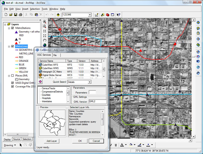
The Carbon Project’s CarbonArc PRO
by Susan Smith
Last week The Carbon Project previewed its new product for OGC Spatial Data Infrastructure (SDI) 1.0 interoperability for ESRI’s ArcGIS 9.2 software, CarbonArc PRO. CarbonArc PRO was preceded by a smaller product to test the market about a year and a half ago, CarbonArc Lite.
 [
Click to Enlarge ] [
Click to Enlarge ] |
“We’ve created a set of products for ArcGIS that supports that SDI 1.0 baseline,” said The Carbon Project president and CEO, Jeff Harrison. For more complicated data producers, SDI 1.0 includes familiar OGC standards such Web Map Server, GML, WFS, and additional unfamiliar things like filters and catalogs, that allow users to put together complex systems much faster and at much lower cost than they have been able to do in the past.
The Carbon Project’s flagship product, CarbonTools PRO, is an extension to the Microsoft .NET framework that supports advanced location content handling, mapping and sharing, and is the underlying toolkit CarbonArc PRO. CarbonArc PRO works only with ArcGIS 9.2 and adds a whole suite of OGC capabilities.
Historically, according to Nuke Goldstein, CTO and COO, OGC has focused on the specifications and server side implementation. “What we try to do in the Carbon Project is focus more on the end users,” Goldstein explained. “What we’re doing is unique because some specifications from OGC did not get much attention. For example, Web Feature Service – Transaction (WFS-T) is a fantastic specification and server capability, that allows end users to affect the data on the service side by creating edits, inserts, updates, etc., yet end users have not done much of this to date. CarbonArc PRO makes it possible to allow users to edit, change, update, and affect data.”
Two main features of CarbonArc PRO for feature data: the transactions and updates just described, and an OGC specification called filter. Filters in SDI 1.0 basically allow people to plug into an online service and retrieve just the information they want. They do this by setting up spatial and other operators. Prior to this product, online services has allowed you to retrieve a lot of data, but not necessarily filtered data. With filters in CarbonArc PRO you can retrieve only the data you need, not only on your desktop, but also out there on the service.
Currently CarbonArc PRO is available only to ArcGIS 9.2 users, but The Carbon Project’s intention is to make the tools available on every Windows based desktop system.
Government agencies are now using the standards and have multiple implementations in place.
“SDI 1.0 is going to be for GIS and geospatial power users, as it is a more professional set of requirements,” said Goldstein. “Although I do think some elements will make their way to the consumer. The trick is to wrap the complexity into something that consumers can use without worrying what GML is or what WFS stands for.”
Google is a good example of how they wrapped complex functionalities under a user friendly interface. KML is somewhat similar in some elements to GML and has its own complexities.
Areas in which SDI applications may find a home could be in oil and gas, insurance, environmental and planning, among professional non-geospatial users.
CarbonArc PRO was also just selected to support the Canadian Geospatial Data Infrastructure (CGDI) Interoperability Pilot. This involves over ten provinces and federal partners working together deploying WFS, with CarbonArc PRO as the main desktop client. “The Canadian project views it as a very important effort for their National Spatial Data Infrastructure.”
CarbonArc PRO makes it easy for users to leverage SDI 1.0 by simplifying all the OGC complexity into a series of easy to use tools. When a user opens CarbonArc PRO they don’t see OGC or specifications, they just see a number of different services they can connect up to like they would see for Yahoo Maps or Google Maps.
The filter and coding specification is like an SQL is for databases. “This is a SQL for WFS, filtering and setting parameters, but it’s a very complicated specification, and it has a very logical language and a lot of functionality hidden inside that specification,” said Harrison. “We wrapped it inside an API in CarbonTools and on top of that we created user interface tools, something we call Filter Builder, and that is a table that people can fill in with their logic parameters and properties and values and create a filter using this easy to use table.”
Harrison said there is a synergy between Google, Microsoft and Yahoo because there are many things that they do not do that OGC does provide in terms of specifications, but there are a lot of things they show OGC that OGC is trying to do. For example, KML and tile based map services have many advantages. OGC is starting to move forward on tile based WMS.
Ultimately, as OGC specifications broaden their reach, more non-geospatial users and consumers may embrace them.
Top News of the Week
ORBIT Geospatial Technologies announced the release of Orbit GIS Photo Locator retail solution.
Orbit GIS Photo Locator autonomously places your photos on Google Earth, Google Maps, and in most GIS systems. Orbit GIS Photo Locator uses the JPG photo EXIF header to extract the position and orientation of the picture at time of taking. The images are immediately converted ready to be used in Google Earth, Google Maps, Orbit GIS and most GIS systems by using the industry standard ESRI SHP file format.
Sanborn is now using ESRI's ArcGIS Image Server to provide its clients access to large imagery datasets. By enabling imagery to be quickly served to the Web, ArcGIS Image Server significantly reduces the turnaround time from image capture to review for Sanborn customers' quality assurance (QA) activities.
Acquisitions/Agreements/Alliances
Digital Map Products (DMP) announced a partnership with Seattle-based New Home Trends (NHT) that allows builders and developers to view critical industry data in a web-based visual interface. The two companies are now offering NHT's forecasting data with DMP's LandVision™ software to NHT customers in the Pacific Northwest.
Tele Atlas announced Tele Atlas MultiNet(TM) China, the most complete digital map of the country available with street level coverage for more than 3,000 provincial and county cities. The company also announced it has opened a Display Technology Center in Shanghai, focused on producing visual enhancements such as 3D landmarks, 3D city maps and crossing magnifications for the Asia Pacific region designed to help make navigation systems clear and compelling to end users.
Leica Geosystems Geospatial Imaging’s recent acquisition of IONIC brings the power of the Open Geospatial Consortium (OGC) and the International Standards Organization (ISO) interoperability to a wider customer base.
With this acquisition, Leica Geosystems is committed to provide standards-based geospatial data management solutions to deploy spatial data infrastructures (SDI) and manage the lifecycle of enterprise data. With IONIC’s RedSpider technology, Leica Geosystems meets customers’ OGC/ISO interoperability needs, with plans to integrate the enterprise suite of solutions into new and existing products.
Intermap Technologies Corp. announced that DCSE, Inc., a Geographical Information System (GIS) consulting firm specializing in the development of Web-based information and collaboration portal applications, has renewed their contract to distribute Intermap's 3D digital elevation data and geometric images.
Announcements
Intermap Technologies(TM) Corp. announced that its Intermap Federal Services, Inc. subsidiary has received a USD $12.5 million contract to provide 3D digital elevation data and orthorectified radar imagery for an international project. The project will be accomplished using the Company's proprietary Interferometric Synthetic Aperture Radar (IFSAR) technology. Under the agreement, the Company will collect and deliver radar mapping services for the client over the next eight-months.
The Carbon Project announced its CarbonArc software was selected by GeoConnections to support the Canadian Geospatial Data Infrastructure (CGDI) Interoperability Pilot. CarbonArc is an interoperability extension for ESRI's ArcGIS, the world's most popular geographic information system (GIS).
The Carbon Project is part of the CubeWerx CGDI team ( www.CubeWerx.com). CubeWerx is an industry leader in standards-based web services for geodata publishing and spatial data infrastructure portals.
People
Michael Gauldin has been selected as the public affairs officer for the U.S. Geological Survey (USGS). He will be responsible for media relations and helping to promote effective and strategic communications to support USGS science.
Gauldin previously served as chief of communications for the U.S. Office of Surface Mining Reclamation and Enforcement, where he was responsible for congressional, media and public affairs.
At a special dedication event held at their head office on August 21, DMTI Spatial, a provider of Location Intelligence, honored Dr. Roger Tomlinson for his contribution the development of Geographic Information Systems, a core technology that enables Enterprise-scaled Location Intelligence.
New Products
ThinkGeo LLC announced the release of Map Suite Pocket PC Edition 2.0, a GIS mapping control for the .NET Compact Framework that enables .NET developers to build full-featured mapping presentations for portable devices. Built on the latest .NET Compact Framework 2.0, Map Suite Pocket PC enables non-GIS developers to author mapping applications for portable computing devices such as Pocket PCs and PDAs.
Dell introduced a mobile workstation, the Dell Precision(TM) M6300, designed to free engineers, artists, developers and other professionals to run business-critical applications wherever they go with true desktop-level performance.
The Dell Precision M6300 sports some of the latest technologies - including processors, OpenGL graphics, screen resolutions and memory - to deliver exceptional performance on the go.
ORBIT Geospatial Technologies announced the release of Orbit GIS 4.2 for Windows. Orbit Geospatial Technologies presents Orbit GIS 4.2 for Windows on 32bit and 64bit machines. The Orbit GIS Desktop solution now comes with over 100 new and improved functionalities. Download a copy now here.
Information Builders announced the availability of a WebFOCUS integration solution for ESRI's ArcGIS Server, extending the robust reporting capabilities of its BI solution through the power of geographical information systems.
Image Matters announced the release of a free-ware version of the Integrated Mapping and Analysis Tool, or IMAT. The IMAT, originally developed for the Western Regional Air Partnership (WRAP), is an application suite providing GIS functionality using open standards and cutting-edge technologies with tools for discovering, viewing, analyzing and reporting on multi-source geospatial data. Image Matters' userSmarts® GX provides the IMAT with an interoperability framework to connect to multiple types and instances of OGC Web Services, including Web Mapping Services (WMS), Web Feature Services (WFS), and Web Processing Services (WPS).
Clark Labs announced the release of their Land Change Modeler software extension for ESRI's ArcGIS software.
Released in 2006 within the IDRISI Andes software, the Land Change Modeler was subsequently developed as a separate product for those individuals utilizing the ArcGIS environment.
Garmin has announced the new nüvi 700 series satellite navigation system. With the 700 series Garmin has elegantly combined advanced technology with enhancements to its user interface to ensure an intuitive and easy navigation experience. This is combined with elegant design and an integrated antenna to make it exceptionally compact and stylish. It also comes with traffic warnings to tell you of any congestion ahead and safety camera alerts for mobile as well as fixed cameras.*
Proxix Solutions announced free online lookups via its CATUM Online Web service.
Insurance companies now have free access to a real-time tool that can help them identify and assess risk exposure for an individual property. CATUM Online is a Web service that combines high-precision parcel-level geocoding technology integrated with sophisticated databases to deliver accurate geographic, risk and compliance information for insurers to manage individual property and portfolio risk, analyze and validate losses, and ensure regulatory compliance.
DeLorme announced the release of the XMap® 5.2 GIS Enterprise suite, with breakthrough GPS features that put aerial imagery, recent topographic maps, and GIS layers in the palm of your hand.
This latest XMap release supports the unique Earthmate® GPS PN-20 color-screen receiver. The PN-20 delivers a unique array of data layering and display features that are indispensable for remote navigation, field data collection, and updating GIS data files.
Around The Web
Geotagging links photos to locales CNET News.com September 4, 2007 - Attaching location data to images enables new ways to search photos, give slide shows or be a virtual tourist. For now, early adopters only need apply.
Upcoming Events
| Annual Conference 2007 Remote Sensing and Photogrammetry Society | ||
| Date | : | September 11 - 14, 2007 |
| Place | : | Newcastle University
United Kingdom |
| In recent years remote sensing and photogrammetry have seen a revolution in the technology and range of products available. The focus of the 2007 annual conference will be to explore the means by which these new data sources can be exploited to their full potential. The meeting aims to encompass a broad spectrum of interests, from sensor design and advanced analytical techniques to commercial utilisation and data management. The conference will include sessions sponsored by ISPRS Working Groups I/4 (Airborne digital photogrammetric sensor systems) and IV/9 (Mapping from high resolution data). | ||
| 20th annual GIS in the Rockies conference | ||
| Date | : | September 12 - 14, 2007 |
| Place | : | INVESCO Field at Mile High
Denver, CO USA |
| The Rocky Mountain region's premier geospatial information and technology conference. The 20th annual GIS in the Rockies conference will be held at INVESCO Field at Mile High September 12-14, 2007 | ||
| Annual International Conference and Exhibition - Location Asia 2007 | ||
| Date | : | September 13 - 14, 2007 |
| Place | : | Hotel Kowloon Shangri-La
Hong Kong |
| Location Asia 2007 is an International Conference and Exhibition in the field of positioning, navigation and timing technologies, organised by GIS Development and Co-Organised by Hong Kong Polytechnic University. Navigation and Positioning technology is an enabling utility that can markedly improve human activities. It is a key element fuelling growth in both infrastructure provision and location related business sevices. As we stand at the exciting horizon of ‘Tagged World’, there is a need to create awareness about the potential of navigation and positioning technology and build capacity of the local industry to design and develop products to meet the future requirements. | ||
| Mapping Georgia Communities: An Introduction to GIS and Community Analysis | ||
| Date | : | September 13 - 14, 2007 |
| Place | : | One Glenlake Parkway
Suite 200, Atlanta, GA USA |
| This workshop is customized for each city in which it is taught.
Audience: Beginners, anyone interested in mapping their community | ||
| 2007 PaSDC DATA USER CONFERENCE | ||
| Date | : | September 13, 2007 |
| Place | : | Holiday Inn Harrisburg/Hershey
604 Station Road, Grantville, PA 17028 USA |
| PAMAP is a continuation of a long standing mapping tradition in the United States. The Department of Conservation and Natural Resources-(DCNR) Bureau of Topographic and Geologic Survey (BTGS) has, for more than a century, cooperated in the joint funding and production of the United States Geological Survey (USGS) topographic quadrangle maps. Now, PAMAP is part of an ambitious program of the federal government called The National Map, an effort coordinated by the United States Geological Survey (USGS) to provide publicly available mapping. | ||
| CFGIS Workshop 2007 | ||
| Date | : | September 15 - 18, 2007 |
| Place | : | University of Central Florida
Pegasus Ballroom, Orlando, FL USA |
| The conference brings together governmental, non-profit, and private sector GIS users in the 10 county area to coordinate issues of common concern, encourage data sharing, and present information on current events. Pre-conference events include ESRI authorized training in ArcGIS and URISA workshops. Events include ESRI presentations and workshops, user paper presentations, map gallery exhibits, vendor exhibits, user group meetings, evening social, luncheon, raffles and prizes including lots of software giveaways. | ||
| Defence Imagery 2007 | ||
| Date | : | September 18 - 20, 2007 |
| Place | : | Thistle Marble Arch
London, United Kingdom |
| Defence Imagery brings together the intelligence community within NATO and European countries to address current/future challenges and developments in the collection, exploitation, and dissemination of imagery based intelligence. Defence Imagery offers military case studies from a variety of countries and organisations including end user perspectives. The event also seeks to showcase technological progress and innovative thinking from outside defence with presentations covering disaster management, international and domestic policing, weapons proliferation monitoring, and homeland security. | ||
| Ninth International Conference on Spatial Information Theory | ||
| Date | : | September 19 - 23, 2007 |
| Place | : | Melbourne Business School
Mount Eliza, Melbourne, Australia |
| At the conference, results from recent research are presented and discussions about advanced work in progress take place. The conference program is established by an international and multidisciplinary program committee. Papers are selected through a rigorous review of full paper contributions by internationally renowned reviewers, based on relevance to the conference, intellectual quality, scientific significance, novelty, relation to previously published literature, and clarity of presentation | ||
| Mapping Hawaii Communities: An Introduction to GIS and Community Analysis | ||
| Date | : | September 20 - 21, 2007 |
| Place | : | New Horizons Computer Learning Center
1585 Kapiolani Blvd,Suite 1000 , Honolulu, HI 96814 USA |
| This workshop is customized for each city in which it is taught.
Audience: Beginners, anyone interested in mapping their community | ||
| IMTA (Americas) 2007 Conference & Trade Show | ||
| Date | : | September 23 - 25, 2007 |
| Place | : | Philadelphia
PA USA |
| Join IMTA (Americas) in the heart of America's most historical district. Walk the cobblestone streets and return to days of the colonies. | ||
| NSGIC 2007 Annual Conference | ||
| Date | : | September 23 - 27, 2007 |
| Place | : | The Madison Concourse Hotel
Madison, WI USA |
| The National States Geographic Information Council (NSGIC) is an organization committed to efficient and effective government through the prudent adoption of geospatial information technologies (GIT). Members of NSGIC include senior state geographic information system (GIS) managers and coordinators. Other members include representatives from federal agencies, local government, the private sector, academia and other professional organizations. | ||
| Free and Open Source Software for Geospatial Conference (FOSS4G) 2007 | ||
| Date | : | September 24 - 27, 2007 |
| Place | : | Victoria Convention Center
Victoria, Canada |
| The 2007 Free and Open Source Software for Geospatial (FOSS4G) conference gathers developers and users of open source geo-spatial software from around the world to discuss new directions, exciting implementations, and growing business opportunities in the field of open source geo-spatial software. Focused on the practical "make it work, get it done" world of open source application development, this annual conference boasts a very high concentration of geo-spatial technical opinion leaders | ||
| NASCLA--The Annual Conference | ||
| Date | : | September 25 - 28, 2007 |
| Place | : | The Peabody Hotel
Three Statehouse Plaza, Little Rock, AR 72201 USA |
| The Annual Conference is designed to provide topics of current interest to Board members and staff involved in the regulation of contractors. The conference also provides a forum for participants to interact and exchange information on licensing issues. | ||
| INTERGEO 2007 | ||
| Date | : | September 25 - 27, 2007 |
| Place | : | Leipzig, Germany |
| The annual change of venue is an important factor in the success of the INTERGEO. Running the 13. INTERGEO conference and trade fair in Leipzig gives the event an even greater international importance. | ||
| ESRI European User Conference 2007 | ||
| Date | : | September 26 - 28, 2007 |
| Place | : | Stockholm, Sweden |
| We welcome you to the ESRI European User Conference 2007! We are committed to making this a very special event, not just another conference. If you attend ONE conference 2007, make this the ONE! | ||
| gbaMS Annual Conference & Training | ||
| Date | : | October 1 - 3, 2007 |
| Place | : | Kansas City, MO USA |
| The 2007 GBA Master Series Annual Conference & Training (ACT) will take place October 1-3 in Kansas City, Missouri. We're headed back to our home town this year and we're excited to show it off. | ||
| 23rd Annual New York State GIS Conference | ||
| Date | : | October 1 - 2, 2007 |
| Place | : | 219 Bray Hall, SUNY-ESF
1 Forestry Drive, Syracuse, NY 13210 USA |
| The conference has a long standing tradition of providing attendees with an opportunity to meet fellow New Yorkers active in the GIS field, exchange information and real experiences, and seek solutions to your geographic data management needs. Professional networking opportunities help you develop a network of fellow GIS users which will continue through the years. In the exhibit area, GIS vendors and consultants display the latest in GIS hardware, software, analytical techniques, and services. | ||
| 4th Annual VLS Users Conference, 2007 | ||
| Date | : | October 2 - 3, 2007 |
| Place | : | Missoula, MT USA |
| Visual Learning Systems cordially invites you to take part in the VLS Users Conference to exchange ideas and experiences related to the VLS software: Feature Analyst®, LIDAR Analyst®, and Urban Analyst™. This fourth annual event will be held October 2-3, 2007 in scenic Missoula, Montana. | ||
| 14th Annual South Florida GIS Expo | ||
| Date | : | October 4 - 5, 2007 |
| Place | : | Palm Beach County Convention Center
650 Okeechobee Boulevard, West Palm Beach, FL 33401 USA |
Geographic Information Systems (GIS) is a horizontal technology that intersects all industries. It blends the geographic sciences with information technology. This conference is for the novice to the analyst, the technologist to the executive. Disciplines of interest include:
| ||
| 2007 ESRI Health GIS Conference | ||
| Date | : | October 7 - 10, 2007 |
| Place | : | Firesky Resort & Spa
Scottsdale, AZ USA |
| The Health GIS Conference October 7-10, 2007, in Scottsdale, Arizona, brings health and human services professionals together to share and discuss successful approaches to using geography to improve research, management, policy decisions, public health and hospital preparedness, and health care delivery.
The ESRI Health GIS Conference provides a forum for you to examine specialized capabilities and opportunities for managing and sharing geospatial data and analysis in a GIS framework for community health programs, health care delivery, hospitals, epidemiology, disease surveillance, health research, and more. | ||
| 2007 Electric & Gas User Group Meeting | ||
| Date | : | October 8 - 11, 2007 |
| Place | : | Gaylord Opryland Resort & Convention Center
Nashville, TN USA |
| Be part of the 2007 EGUG annual meeting October 8–11, 2007 in Nashville, Tennessee, to explore how GIS serves electric and gas utilities. Discussions will examine desktop usability, spatial data management, server-based GIS, mobile solutions, and Web services. | ||