
Warning: Undefined array key "upload_with_nude_flag" in /www/www_com/htdocs/get_weekly_feature_ad.inc.php on line 69
Welcome to GISWeekly! This week our Industry News features a story on the OGC and the World Wide Web Consortium and their efforts to step up collaboration by Carl Reed.
GISWeekly examines select top news each week, picks out worthwhile reading from around the web, and special interest items you might not find elsewhere. This issue will feature Industry News, Top News of the Week, Acquisitions/Alliances/Agreements, Announcements, New Products, and Events Calendar.
GISWeekly welcomes letters and feedback from readers, so let us know what you think. Send your comments to me at giscafe-editor@IBSystems.com
Best wishes,
Susan Smith, Managing Editor
Industry News
The OGC and the World Wide Web Consortium Step Up Collaboration
by Carl Reed
Chief Technology Officer
Open Geospatial Consortium, Inc
tel: +1-970-419-8755
creed@opengeospatial.org
In 2003, the World Wide Web Consortium ( W3C) Semantic Web Interest Group published the “ Basic Geo Vocabulary”. The W3C is the standards organization that has developed and promoted essential Web standards such as HTML, XML, and others. “Basic Geo” is a specification that provides a “namespace” for representing latitude, longitude and elevation, using WGS84 as a reference datum.
This Geo note is not currently a W3C recommendation, and has not been subject to the associated review process, but it is being used in a variety of Web applications.
Many web developers were content with using Basic Geo in their applications. However, over time, Web developers discovered that they often require more capabilities than just expressing points. There is also the need to express, lines, polygons and coordinate reference systems. As GIS professionals can easily imagine, even basic location-based applications might require concepts like “route,” “is near,” “touches,” and “intersects,” and these capabilities are not supported in the Basic Geo vocabulary.
Fortunately, the OGC has, since 1994, engaged users and providers of geospatial technology in a standards process that has produced a wide range of geospatial standards. These include very simple “lightweight” profiles of the comprehensive XML-based OpenGISÆ Geography Markup Language (GML) Specification. These profiles provide needed guidance and information models required to update Basic Geo. Indeed, most of the geospatial standards developed and adopted by the OGC membership since 1998 have been built on Web standards from the W3C, OASIS and other organizations. Most of these are in the suite of standards that the OGC calls “OGC Web Services.”
The W3C is currently focused on an effort to specify ways of encoding natural language that enable much “smarter” searches. Their goal is the “Semantic Web.” Last year, the Open Geospatial ConsortiumÆ (OGC) became a member of the W3C and initiated a W3C incubator called Geospatial XG to focus attention on semantic geospatial issues.
Within the W3C, Incubator Activities like the Geospatial XG facilitate rapid development, on a time scale of a year or less, of new Web-related concepts. W3C members OGC, SRI International, University of Southern California Information Sciences Institute (USC ISI), Stanford University, and Oracle are sponsors of the Geospatial XG. Joshua Lieberman (Traverse Technology) chairs the group (Josh has also been active in the OGC since 1999). The expectation is that the work of the Geospatial XG will lead to collaborative “Geospatial Semantic Web” specification development involving the W3C and the OGC.
As GIS professionals know, metadata, vocabularies, and data model standards have long been an important focus of research and development in the geospatial world. GML, the OpenGISÆ Catalog Services Specification and other OGC standards leverage this distributed body of published knowledge and industry expertise and provides for capturing and expressing a basic level of geo-semantic context.
The first technical goal of the Geospatial XG is to address GeoRSS, a useful specification that was defined and released last year through an independent grassroots effort to provide the ability to encode “place” in RSS (“real simple syndication”) feeds. One serialization of GeoRSS already uses GML. (See sidebar.) The goal of the Geospatial XG activity is to make GeoRSS also work in an optimal way with the W3C’s Web Ontology Language (OWL) .
|
|
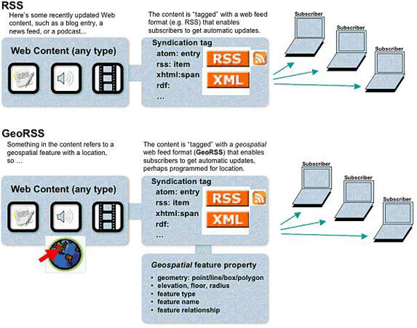
Figure shows RSS “geospatially enabled” with GeoRSS. GeoRSS places no constraint on the type of syndication format. That is, it is not limited to RSS, but can be applied to other types of tags. (For the UML model of GeoRSS, see http://www.georss.org/model.html )
GeoRSS is a significant enhancement beyond the W3C’s 2003 Basic Geo Vocabulary. Basic Geo provided only a fairly coarse spatial indexing capability, whereas the GeoRSS update supports a fuller sense of geographic representation, letting people add a feature "view" to any Web-accessible resource.
One might say that Basic Geo and GeoRSS are in a way the converse of traditional “GIS centricity”. They both support addition of feature properties to information, while traditional geo-centric models focus on adding information (properties) to features.
|
GML Profiles
1. The GML Point Profile is just five pages long. It is too limited to encode polygons or routing instructions, but many location-based services (LBS) applications work with just a coordinate pair that identifies the location of a device. Such devices are typically small and are expected to receive and send data quickly, so the data needs to be as compact as possible. The GML Point Profile is currently an OGC Discussion Paper. 2. The specification for a proposed GML Profile for GeoRSS fills fewer than 10 pages. RSS (Really Simple Syndication or Rich Site Summary) is a tool that enables Web users to subscribe to information updates from Web servers. The GML profile for GeoRSS ( GeoRSS) defines a GML-based structure to store spatial information in RSS web feeds. GeoRSS GML includes just four geometry types: point, line, polygon and box. GeoRSS was developed via consensus of a number of interested geospatial and IT professionals and is not currently an approved OGC specification. 3. The OpenGIS Æ GML Simple Feature Profile (GML SF) Specification, approved in 2006, is 31 pages in length (plus boilerplate and annexes). Its rules allow encoding of only simple feature geometries: points, lines, polygons and a few other geometry types. This subset is particularly useful for applications that intend to use the OpenGIS Web Feature Service Implementation Specification to define an interface for sharing and editing vector data. 4. GML in JPEG 2000 for Geographic Imagery Encoding Specification provides information related to an image, including image location. ISO, under whose auspices the JPEG 2000 Specification was developed, left a "box" available for storing such information. Encoding information about an image in GML provides a standard way for applications to find and use the image. |
In terms of consortium process, the first goal of the Geospatial XG is to develop a W3C "Note" based on GeoRSS version 1. This will result in a W3C Web page describing GeoRSS in the context of both W3C standards, such as XML, HTML, and OWL, and OGC's relevant work, such as GML and the OpenGIS Abstract Specification.
The longer-term goal of the Geospatial XG is to improve collaboration between the W3C and the OGC with the objective that geospatial capabilities will ultimately be an integral, transparent and fully optimized component of the Web. The complexity and importance of geospatial technology are often not appreciated and are not easily understood without mutual consideration. Ultimately, the OGC and the W3C expect to collaboratively add geospatial content and context to the emerging Semantic Web in a manner that is consistent with existing and future OGC and W3C standards.
Collaboration between standards activities is important to both the geospatial and IT communities. In the last decade, open consensus-based standards have made great strides in replacing more restrictive and problematic proprietary standards. But the information and communications technology industry is in rapid flux, and the era of open standards will not continue without active and widespread participation in the key consensus processes.
Interested parties are invited to participate in the Geospatial XG public mailing list. OGC's members are also invited to provide input on W3C issues to the OGC W3C Liaison, Raj Singh ( Email Contact ).
Top News of the Week
The City and County of San Francisco announced the development and launch of a city-wide, dynamic online map of the city's growing number of trees. Autodesk, Inc. through the Mayor's Office of City Greening, worked together with the City's Bureau of Urban Forestry (BUF) and Friends of the Urban Forest (FUF), a local San Francisco non-profit organization, to develop this Urban Forest Mapping System, which will serve as a central dynamic resource where San Francisco residents, community groups and city employees can update and share information about new or existing street trees that form part of the city's urban forest.
The Brooks Act litigation and other issues affecting Federal procurement of surveying and mapping services will be the subject of a special presentation by John Palatiello at the ACSM Convention on Monday, March 12, in St. Louis.
Palatiello, who serves as the Executive Director for MAPPS and Administrator of the Council on Federal Procurement of Architectural & Engineering Services (COFPAES), is scheduled to speak at 8 am on March 12, 2007. For more information, visit the ACSM website
Alliances/Acquisitions/Agreements
DigitalGlobe(R announced several strategic initiatives for its commercial business unit. The upgraded roadmap includes a new Boston, Mass. commercial office, along with plans to integrate assets from the recent acquisition of GlobeXplorer and provide non-government technology sectors, such as real estate, internet portals, and location-based services quicker, easier access to the company's digital imagery products.
Announcements
The 2007 Location Intelligence Conference, the premiere industry event focused on the use of location technology, announced that Kanwar Chadha, founder of SiRF Technology Holdings, Inc., will deliver the keynote address on Wednesday, April 18 at 9:15 AM PDT. Chadha will discuss the ways in which enterprises can benefit by deploying location technology across a range of applications to improve their business operations and profitability.
The 2007 Location Intelligence Conference will take place April 16-18, 2007 at the Parc 55 Hotel in San Francisco. For more information, visit the Location Intelligence website.
GITA, the Open Geospatial Consortium, the National Institute of Building Sciences, and the Web 3D Consortium present Emerging Technology Summit IV. This event is set to take place in Washington, D.C., March 21-23, 2007. See the full preliminary program, and register for the conference now!
PCI Geomatics® is pleased to announce that it has successfully completed the Web Coverage Service test suite from the Open Geospatial Consortium, Inc.® (OGC) for their product Geomatica® WebServer Suite – Web Coverage Server (WCS), Version 10.0.3.
A world leading developer of image-centric software and solutions for the geospatial industry, PCI’s Web Coverage Server is compliant with the OpenGIS® Web Coverage Service Implementation Specification 1.0.0.
The U. S. Geological Survey (USGS) in collaboration with the National Aeronautics and Space Administration (NASA) and the British Antarctic Survey (BAS) is developing a unique and versatile map of Antarctica using satellite imagery. The Landsat Image Mosaic of Antarctica or LIMA combines nearly 1100 hand-selected Landsat satellite scenes that are being digitally woven together to create a single, seamless, cloud-free image of the Antarctic continent—the most detailed color representation of this vast and frozen landmass ever produced. The National Science Foundation is funding the LIMA project.
ESRI (UK) has announced dates for GIS Tech 2007 which this year will include a new awards ceremony for excellence in GIS.
The two day conference will take place on 24-25 April 2007 at the East Midlands Conference Centre, University of Nottingham.
New Products
P2 Energy Solutions announces the release of Tobin GIS Studio - Spatial Data Creation version 1.1 (TGS-SDC); an intuitive tool that enables the user to create and display spatial representations of land assets and facilitate spatial analysis of these assets. TGS-SDC is the spatial data creation component of the Tobin GIS Studio suite of products. The TGS-SDC application, an extension of ESRI's ArcGIS Desktop products (ArcGIS Desktop), integrates with P2 Energy Solutions' land asset management products, other OLE-compliant databases and ASCII files to provide a scalable, compatible GIS solution with land asset management systems.
deCarta announced the launch of a turn-key navigation application for use in personal navigation devices (PNDs). The new navigation application allows manufacturers of PNDs and smartphones to bring a custom-branded navigation application to market quickly and with minimal development time.
A wholly owned subsidiary of Fairfield Industries, RFTrax is a breakthrough provider of remote asset management telemetry to freight transportation companies. Its first product, the Asset Management Platiform™ (AMP) for locomotives, gives railroads the opportunity to “see” exactly what is happening to any locomotive equipped with a special RFTrax transceiver known as an Asset Command Unit (ACU).
SkyPilot Networks, provider of carrier-class broadband wireless mesh networks, introduced version 1.5 of the SkyControl(TM) mesh management system, which integrates seamlessly with the Google Earth(TM) mapping service. Using the GPS positioning capabilities of SkyPilot's mesh infrastructure products, the new functionality provides automatic and dynamic mesh network visualization within the Google Earth Pro application, the commercial version of the free Google Earth application. Combining these two powerful tools provides service providers and municipalities with more flexibility in designing, building and operating wireless mesh networks.
LeadDog Consulting, an international provider of street and road maps announced the release of detailed city street geographic databases for the Algerian cities: Algiers, Oran, Annaba, Setif, Bordj Bou Arereridj, Mascara, Mostagenem, Tebessa, and Tlemcen. LeadDog maps are in use in a wide range of applications from military and government emergency and defense support to commercial fleet management and location based services. LeadDog products provide accurate base level mapping and numerous vector layers and attributes such as:
- Streets at 1:10,000 scale
- Street names
- Street classifications
- Extensive Points of Interest (airports, hospitals, government offices, etc…)
- Water and Landmark polygons
- Political division and borders
Compass Scout is the latest addition to the Compass data management suite of products and is designed to manage personal MapInfo Professional datasets.
Effective data management is important to all organizations and up until now data management tools have been limited to large enterprises. The introduction of Compass Scout breaks down this barrier by offering users a free, easy to use tool to manage MapInfo Professional spatial data. Compass Scout increases productivity by ensuring local datasets are catalogued, readily accessible and effortlessly located. Costly data duplication is eliminated.
Digital mapping and geographic information systems (GIS) software developer Cadcorp has announced a new, easy-to-use free application for viewing Pictometry® oblique view imagery within Cadcorp SIS – Spatial Information System. The new Cadcorp SIS Pictometry Viewer, developed by Cadcorp using Pictometry’s software development kit is available for use with Cadcorp SIS desktop products, including Map Modeller, Map Editor and Map Manager.
Harte-Hanks Global Address, the international address quality solution from Harte-Hanks, Inc. has released a new software version with geospatial modules that enable users to "find my nearest," plan a route from "A" to "B" and perform mapping functions.
Avenza Systems Inc., producers of MAPublisher cartographic software for Adobe Illustrator and Geographic Imager spatial tools for Adobe Photoshop announces the release of MAPublisher 7.3 for Adobe Illustrator CS2. MAPublisher 7.3 is the latest version of this powerful mapmaking software used to produce high quality maps from GIS data and is the first version to offer support for enhanced Unicode character encoding.
GeoAge, Inc. announces the release of the Field Adapted Survey Toolkit (FAST) version 3.1.
FAST now includes file attachment with mobile forms. This provides the ability to integrate video, audio and other document types with digital forms, GPS, and signatures.
Optech Incorporated’s Industrial & 3D Imaging Division and Applied Imagery announces the release of Version 6.0.0 Quick Terrain Modeler software.
In an ongoing strategic partnership, Optech will continue to provide Applied Imagery’s Quick Terrain Modeler Software with Automated Alignment functionality as a standard tool in Optech’s line of Intelligent Laser Ranging and Imaging Systems (ILRIS) at no additional cost.
Wallingford Software announces the release of Version 8.0 of InfoWorks, the leading software solution for modeling, infrastructure planning and operational management in the water, wastewater and river management sectors. The launch is in line with Wallingford Software’s commitment to issue two major software releases each year, offering users new functions, time-saving features, performance advances and enhanced presentation of information across the whole InfoWorks family - InfoWorks CS for wastewater management and sewerage provision, WS for water distribution and supply and RS for river, channel and floodplain flows.
Upcoming Events
| ESRI Business Partner Conference | |
| Date: | March 17 - 19, 2007 |
| Place: | Palm Springs, CA USA |
| ESRI's community of business partners is on the forefront of the GIS solutions and enterprise revolution. These innovative companies are helping drive the future of the GIS industry. Join ESRI and your colleagues in this exclusive opportunity to network and share ideas. | |
| ESRI Developer Summi | |
| Date:
|
March 19 - 22, 2007 |
| Place:
|
Wyndham Hotel and Convention Center
Palm Springs, CA USA |
| Attend in-depth technical presentations led by ESRI staff who will give guidance on and insights into both intermediate and advanced topics | |
| AIAA 5th Missile Defense 2007 | |
| Date: | March 19 - 22, 2007 |
| Place: | Ronald Reagan Building and International Trade Center
Washington, DC USA |
| The 5th Annual U.S. Missile Defense Conference will continue to build and strengthen Ballistic Missile Defense System (BMDS) Team relationships that will in turn make development of a global missile defense system a successful reality. | |
| OGC/GITA Emerging Technology Summit | Orange County Convention Center
Orlando, FL USA |
| CTIA WIRELESS is the world’s largest telecommunications event dedicated exclusively to wireless, broadband convergence and mobile computing technologies, covering the entire industry from network infrastructure to microprocessors to applications to content to end-user hardware. | |
| GIS Evolutions 2007 | |
| Date: | March 27 - 28, 2007 |
| Place: | Swissotel Sydney
68 Market Street, Sydney , Australia |
| From environmental impact assessment and emergency response, to Australia’s biggest road construction project and the introduction of Google Earth, ‘GIS Evolutions’ 2007 reflects the gradual expansion of GIS use from fringe to enterprise-wide applications, and promises to be as fascinating and invaluable as ever. | |
| 9th Crime Mapping Research Conference | |
| Date: | March 28 - 31, 2007 |
| Place: | Omni William Penn Hotel
Pittsburgh, PA USA |
| The use of Geographic Information Systems (GIS) and spatial data analysis techniques have become prominent tools for analyzing criminal behavior and the impacts of the criminal justice system on society. Classical and spatial statistics have been merged to form more comprehensive approaches in understanding social problems from research and practical standpoints. | |
You can find the full GISCafe.com event calendar here.
To read more news, click here.
-- Susan Smith, GISCafe.com Managing Editor.