
Warning: Undefined array key "upload_with_nude_flag" in /www/www_com/htdocs/get_weekly_feature_ad.inc.php on line 69
Welcome to GISWeekly!
GISWeekly examines select top news each week, picks out worthwhile reading from around the web, and special interest items you might not find elsewhere. This issue will feature Industry News, Top News of the Week, Acquisitions/Agreements/Alliances, Announcements, People, New Products, Around the Web and Events Calendar.GISWeekly welcomes letters and feedback from readers, so let us know what you think. Send your comments to me at Email Contact
Best wishes,
Susan Smith, Managing Editor
Industry News
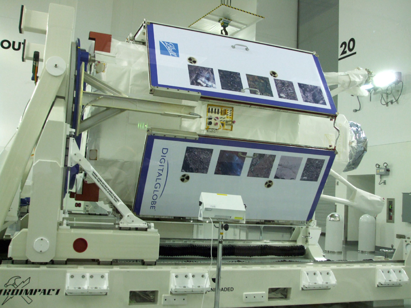
WorldView-1 Launch Date Announced
by Susan Smith
 [
Click to Enlarge ] [
Click to Enlarge ] |
Chuck Herring, director, Corporate Communications for DigitalGlobe, talked about the satellite, which is part of the National Geospatial-Intelligence Agency (NGA)’s NextView program.
GISWeekly: Do you have customers lined up and ready, looking forward to using the data this satellite will produce?
Chuck Herring: Obviously the NGA is one as this satellite will service the NextView contract, and they’re very eager to start to receive the data. We do have customers around the world as well. The big differentiator with WorldView 1 is the fact that it collects 4-5 times more imagery than QuickBird currently collects. There are many regions of the world where our biggest problem is being able to collect because of a scarcity of capacity. For people collecting the large areas of the U.S., middle East, Europe, Asia, especially in developing areas, the biggest issue is being able to collect their imagery in a timely fashion. Having two satellites up there will help address that capacity issue. It’s not as though there’s a drastic jump in the resolution of the imagery. We’re going from .6 meter from .5 meter. It’s more just being able to address the overall customers’ demand and being able to address our capacity needs. At this point we’d love get WorldView-2 up as soon as possible but obviously there are schedules involved in the construction of satellites.
 [
Click to Enlarge ] [
Click to Enlarge ] |
GW: Will the NGA be on your main customer on WorldView-2 as well?
CH: No, they’re interested in all different sources of data. They deal with foreign providers and different sources of imagery, so any time new sources come online they will be very interested. WorldView-2 was financed by DigitalGlobe and is independent of any contracts, so while we do anticipate they’ll have an interest in WorldView-2 we don’t have a contract in place for them to purchase WorldView-2 currently.
GW: What determines which satellite customers might require or would best meet their needs?
 [
Click to Enlarge ] [
Click to Enlarge ] |
I think as we anticipate working with our partners and end users, there’ll be a mix, some will be placing order saying whichever satellite has the opportunity to collect it first, please select this area. Others will specify one satellite or the other, it depends on end users; application and what they want collected and how timely. We may run into occasions where they want QuickBird and they have timelines and they want to shift over to WorldView because they’re able to get it collected.
GW: Your ImageLibrary will probably be growing exponentially with this new satellite and with GlobeXplorer. Do you have any idea how fast it will be growing?
CH: On average, on a daily collection, we’ll be collecting about four to five times the amount of imagery, We usually collect about 500 images per day, so on the order of about 2,000 images per day. It is a drastic uptake in the amount of imagery we’re collecting. To date, we’re definitely over 300 million square kilometers that have been collected by QuickBird. Our acquisition of GlobeXplorer, which also includes the Airphoto library, was a significant portion of aerial imagery, so our library right now is very robust and will grow exponentially once WorldView is up there. The other thing to consider is that WorldView-2 will collect four to five times the amount of imagery, so with both of those up there at the same time we would be collecting about 10 times what we’re currently collecting with QuickBird.
GW: Tell me about your relationship with Google Earth.
CH: It originally started with our relationship with Keyhole way back, and grew significantly. We’re one of the most significant providers to Google Earth. We’re kind of the default, high resolution, world wide provider of satellite imagery for Google mapping products.
In general, there has been a shift in awareness, in internet mapping and its availability, not only in the maps but the imagery behind it. We’ve grown it into other sectors. With our acquisition of GlobeXplorer, they had relationships with Zillow, and others, and since then we’ve been working with several different sectors, personal navigation, etc. We’ve made announcements about our relationship with Garmin and Lowrance, so we’re seeing because people have an expectation to see imagery with their mapping products it’s now creeping into many areas other than just internet mapping, in personal nav, etc.
Whether it’s the personal handheld nav, or marine, or car navigation, that’s what Lowrance is doing on the marine side, and they can use our imagery along coastlines to again put context in their mapping. We’re seeing demand grow, we’re seeing it on a smaller scale and it grows with each one of these relationships.
GW: How much of your business is consumer?
CH: We don’t do a lot of direct consumer. Consumers are looking at our imagery through Google and personal nav and internet mapping. We can’t put a number to it but the percentage of revenue is small because we generally do it through a channel or through large partners like Google or Garmin and they’re not selling imagery, it’s just packed for end use.
GW: Is the bulk of your business still with the government?
CH: It’s shifted a bit. In early operations we were probably 80/20 as far as government vs. commercial and now we’re about 60/40. That will skew back towards a significant portion of it being government again with the launch of WorldView-1 just because of the nature and size of the NextView contract. There is a big uptake in the consuming of imagery based on the NextView contract and the WorldView-1 collection capability.
We always viewed this as a commercial industry and we focused on that. It takes a lot of time to grow that commercial side, and we’re seeing significant growth on the government side, both are growing.
GW: What is the benefit to DigitalGlobe to be the sole owner of WorldView-2?
CH: With WorldView-2 and our efforts in the commercial marketplace, with all government users and other foreign governments, it gives us a lot more flexibility on how we allocate the capacity, so going into launch we have the ability to assess our different customer sets and decide who gets what portions of the capacity. It just gives us more flexibility in the planning, licensing, and pricing, to have it financed by DigitalGlobe, and if you step back and look, QuickBird 1 and 2 were financed by DigitalGlobe. Going into operations, we had a lot more flexibility in contract negotiations, licensing, pricing, how we allocated capacity. It was a little different as it was a new industry from a satellite standpoint, although aerial was out there. This was a new source and new industry, so the overall demand wasn’t quite as much and we had to build and create that demand. Now that we have done that, there will be more requests for capacity as we get closer to launch.
Top News of the Week
Tele Atlas, a global provider of digital maps and dynamic content for navigation and location-based solutions, and Travel Channel Media, an integrated travel media business, wholly owned by Cox Communications, Inc., announced an exclusive agreement to make rich text, audio and visual content from the Travel Channel available for Tele Atlas digital map users worldwide.
Acquisitions/Agreements/Alliances
Lockheed Martin announced the signing of a cooperative marketing agreement with FortiusOne, a geospatial analytics company. FortiusOne provides next- generation intelligent mapping services that offer a new level of geographic information for the user.
Under the agreement, Lockheed Martin will have the exclusive marketing rights for FortiusOne's products to intelligence, defense and homeland security customers. Lockheed Martin will also integrate the company's products into existing and future programs.
SPADAC, the premier provider of innovative predictive and geointelligence analysis solutions for government and industry, announced that it has acquired EarthWhere technology from SANZ. Based in Englewood, Colorado, SANZ is a leading provider of data access solutions focused exclusively on the design, deployment and support of business critical IT environments for corporations and government agencies. SANZ is a subsidiary of SAN Holdings, Inc.
Digital Map Products announced that it has added ZipRealty and CoStar Group to its growing list of high-profile clients choosing ParcelStream™. Digital Map Products (DMP) debuted its ParcelStream™ web service late last year as part of Fidelity National Real Estate Solutions' Cyberhomes. Since then, there has been a tremendous response to the company's cost-effective solution for the acquisition and visualization of parcel boundaries.
Announcements
Tele Atlas announced the Tele Atlas Maps in Apps 2007 contest is now accepting applications. Maps in Apps is part of the Tele Atlas LBS Innovators Series, an ongoing program held in conjunction with Tele Atlas DeveloperLink(SM) to help foster innovation and enable application developers to increase their visibility, credibility and success with key participants in the industry including investors, carriers and technology providers. To learn more about the Tele Atlas LBS Innovators Series including submission instructions, please visit the
website.
MAPPS and ASPRS praised the Bush Administration for its commitment to land remote sensing with the release of the National Land Imaging Program (NLIP) strategy by the Office of Science and Technology Policy (OSTP).
This program is designed to meet U.S. civilian moderate resolution land imaging needs to monitor the changes in land surface, Polar Regions, and coastal zones due to the changes in population growth, development and climate changes. It establishes a program office in the Department of the Interior, reporting at the Secretary and Assistant Secretary level, to provide focused leadership and management for the nation’s land imaging efforts.
People
GeoAnalytics® Inc., an IT consulting firm that specializes in the planning, design, and implementation of spatial intelligence systems, announced that Dave Mockert has joined the firm as Director of Local and State Practice.
Snowflake Software takes pleasure in introducing the latest member of its team, Daniel Hardwick, to its pre-sales support infrastructure. Daniel brings to Snowflake a wealth of experience in both GIS and geology, providing a perfect knowledge base for the company’s growing user group. Having lived in New Zealand, Australia and Brazil, he also expands the already international community of Snowflake’s personnel.
GeoEye, a producer of satellite, aerial and geospatial information, announced the appointment of Roberta E. ("Bobbi") Lenczowski to its Board of Directors. Ms. Lenczowski's career as an executive of the National Geospatial- Intelligence Agency (NGA) included most recently serving as NGA's Technical Executive and West Senior Executive.
New Products
The members of the Open Geospatial Consortium, Inc. (OGC) have approved the OpenGIS(R) Styled Layer Descriptor (SLD) Implementation Specification (a profile of the Web Map Service) and the related OpenGIS Symbology Encoding Implementation Specification.
The OpenGIS(R) Styled Layer Descriptor (SLD) profile of the Web Map Service Implementation Specification defines an encoding that extends the Web Map Service specification to allow user-defined symbolization of feature and coverage data. It allows users to determine which features or layers are rendered with which colors or symbols.
ESRI’s ArcGIS Business Analyst desktop software now includes ESRI’s 2007/2012 demographic data update and segmentation, business, and shopping center data. This data update, available today, is the most current and accurate information about the U.S. population. The software innovations delivered at the 9.2 release, coupled with this update to the industry’s best datasets, create the optimal business analysis solution that is ArcGIS Business Analyst.
QCoherent Software, provider of Limitless LIDAR™ software tools, announces the release of LP360 v1.5 and LP360 Classify v1.5. With an advanced architecture for accessing and processing LIDAR points, LP360 has quickly become the LIDAR tool of choice for integrating LIDAR point clouds into ArcGIS. LP360 v1.5 provides ESRI users with unique new abilities to functionally leverage enormous LIDAR point cloud datasets into sophisticated geospatial analysis.
Google announced the launch of Sky, a new feature that enables users of Google Earth to view the sky as seen from planet Earth.
With Sky, users can now float through the skies via Google Earth. This easy-to-use tool enables all Earth users to view and navigate through 100 million individual stars and 200 million galaxies. High resolution imagery and informative overlays create a unique playground for visualizing and learning about space.
NAVTEQ, a global provider of digital map data for location-based solutions and vehicle navigation, has announced the launch of Digital Terrain Model and Satellite Imagery which enable richer, more realistic map display in location-based and navigation applications. These are in addition to NAVTEQ's 2D Landmark Footprints, Enhanced 2D Footprints, 3D City Models and 3D Landmark products.
Around the Web
Laptop etiquette takes to the skies, August 21, 2007, USA Today
Upcoming Events
| AGI User Exchange | |
| Date: | August 28 - 29, 2007 |
| Place: | Washington, DC USA |
| You’re invited to attend the 2007 AGI User Exchange, being held August 28-29 at the Renaissance Mayflower Hotel in Washington, D.C. This is the only time this year when AGI will offer such a free event. Share and gain knowledge of AGI software technologies | |
|
| |
| 2nd Indonesian Geospatial Technology Exhibition | |
| Date: | August 29 - September 1, 2007 |
| Place: | Assembly Hall
Jakarta Convention Center, Pusat DKI , Jakarta , Indonesia |
| Geospatial data and technology are also required for constructing a sound spatial planning, to ensure that the development activities of a certain area will take into account all necessary aspects, especially the environmental aspect. This in turn will minimize the negative effects that may arise because of the development process. | |
|
| |
| Council on Licensure, Enforcement and Regulation (CLEAR) | |
| Date: | September 6 - 8, 2007 |
| Place: | Atlanta, GA USA |
| CLEAR invites your involvement in our 27th annual conference, "Promoting Regulatory Excellence." We are accepting session proposals relating to critical issues in professional regulation that are designed to help our attendees carry out their vital shared mission of public protection | |
|
| |
| APWA International Public Works Congress & Expo | |
| Date: | September 9 - 12, 2007 |
| Place: | Henry B. Gonzales Convention Center
San Antonio, TX USA |
| APWA invites you to join us at the 2007 Congress! We’re combining the Best Show in Public Works with the Big State of Texas to bring you the “Biggest and Best Show in Public Works!” Join us in San Antonio to mingle with your peers and learn how you can improve your agency’s performance. | |
|
| |
| Annual Conference 2007 Remote Sensing and Photogrammetry Society | |
| Date: | September 11 - 14, 2007 |
| Place: | Newcastle University
United Kingdom |
| In recent years remote sensing and photogrammetry have seen a revolution in the technology and range of products available. The focus of the 2007 annual conference will be to explore the means by which these new data sources can be exploited to their full potential. The meeting aims to encompass a broad spectrum of interests, from sensor design and advanced analytical techniques to commercial utilisation and data management. The conference will include sessions sponsored by ISPRS Working Groups I/4 (Airborne digital photogrammetric sensor systems) and IV/9 (Mapping from high resolution data). | |
|
| |
| 20th annual GIS in the Rockies conference | |
| Date: | September 12 - 14, 2007 |
| Place: | INVESCO Field at Mile High
Denver, CO USA |
| The Rocky Mountain region's premier geospatial information and technology conference. The 20th annual GIS in the Rockies conference will be held at INVESCO Field at Mile High September 12-14, 2007 | |
|
| |
| Annual International Conference and Exhibition - Location Asia 2007 | |
| Date: | September 13 - 14, 2007 |
| Place: | Hotel Kowloon Shangri-La
Hong Kong |
| Location Asia 2007 is an International Conference and Exhibition in the field of positioning, navigation and timing technologies, organised by GIS Development and Co-Organised by Hong Kong Polytechnic University. Navigation and Positioning technology is an enabling utility that can markedly improve human activities. It is a key element fuelling growth in both infrastructure provision and location related business sevices. As we stand at the exciting horizon of ‘Tagged World’, there is a need to create awareness about the potential of navigation and positioning technology and build capacity of the local industry to design and develop products to meet the future requirements. | |
|
| |
| Mapping Georgia Communities: An Introduction to GIS and Community Analysis | |
| Date: | September 13 - 14, 2007 |
| Place: | One Glenlake Parkway
Suite 200, Atlanta, GA USA |
| This workshop is customized for each city in which it is taught.
Audience: Beginners, anyone interested in mapping their community | |
|
| |
| 2007 PaSDC DATA USER CONFERENCE | |
| Date: | September 13, 2007 |
| Place: | Holiday Inn Harrisburg/Hershey
604 Station Road, Grantville, PA 17028 USA |
| PAMAP is a continuation of a long standing mapping tradition in the United States. The Department of Conservation and Natural Resources-(DCNR) Bureau of Topographic and Geologic Survey (BTGS) has, for more than a century, cooperated in the joint funding and production of the United States Geological Survey (USGS) topographic quadrangle maps. Now, PAMAP is part of an ambitious program of the federal government called The National Map, an effort coordinated by the United States Geological Survey (USGS) to provide publicly available mapping. | |
|
| |
| CFGIS Workshop 2007 | |
| Date: | September 15 - 18, 2007 |
| Place: | University of Central Florida
Pegasus Ballroom, Orlando, FL USA |
| The conference brings together governmental, non-profit, and private sector GIS users in the 10 county area to coordinate issues of common concern, encourage data sharing, and present information on current events. Pre-conference events include ESRI authorized training in ArcGIS and URISA workshops. Events include ESRI presentations and workshops, user paper presentations, map gallery exhibits, vendor exhibits, user group meetings, evening social, luncheon, raffles and prizes including lots of software giveaways. | |
|
| |
| Defence Imagery 2007 | |
| Date: | September 18 - 20, 2007 |
| Place: | Thistle Marble Arch
London, United Kingdom |
| Defence Imagery brings together the intelligence community within NATO and European countries to address current/future challenges and developments in the collection, exploitation, and dissemination of imagery based intelligence. Defence Imagery offers military case studies from a variety of countries and organisations including end user perspectives. The event also seeks to showcase technological progress and innovative thinking from outside defence with presentations covering disaster management, international and domestic policing, weapons proliferation monitoring, and homeland security. | |
|
| |
| Ninth International Conference on Spatial Information Theory | |
| Date: | September 19 - 23, 2007 |
| Place: | Melbourne Business School
Mount Eliza, Melbourne, Australia |
| At the conference, results from recent research are presented and discussions about advanced work in progress take place. The conference program is established by an international and multidisciplinary program committee. Papers are selected through a rigorous review of full paper contributions by internationally renowned reviewers, based on relevance to the conference, intellectual quality, scientific significance, novelty, relation to previously published literature, and clarity of presentation | |
|
| |
| Mapping Hawaii Communities: An Introduction to GIS and Community Analysis | |
| Date: | September 20 - 21, 2007 |
| Place: | New Horizons Computer Learning Center
1585 Kapiolani Blvd,Suite 1000 , Honolulu, HI 96814 USA |
| This workshop is customized for each city in which it is taught.
Audience: Beginners, anyone interested in mapping their community | |
|
| |
| IMTA (Americas) 2007 Conference & Trade Show | |
| Date: | September 23 - 25, 2007 |
| Place: | Philadelphia
PA USA |
| Join IMTA (Americas) in the heart of America's most historical district. Walk the cobblestone streets and return to days of the colonies. | |
|
| |
| NSGIC 2007 Annual Conference | |
| Date: | September 23 - 27, 2007 |
| Place: | The Madison Concourse Hotel
Madison, WI USA |
| The National States Geographic Information Council (NSGIC) is an organization committed to efficient and effective government through the prudent adoption of geospatial information technologies (GIT). Members of NSGIC include senior state geographic information system (GIS) managers and coordinators. Other members include representatives from federal agencies, local government, the private sector, academia and other professional organizations. | |
You can find the full GISCafe.com event calendar here.
To read more news, click here.
-- Susan Smith, GISCafe.com Managing Editor.