
Warning: Undefined array key "upload_with_nude_flag" in /www/www_com/htdocs/get_weekly_feature_ad.inc.php on line 69
Welcome to GISWeekly!
GISWeekly examines select top news each week, picks out worthwhile reading from around the web, and special interest items you might not find elsewhere. This issue will feature Industry News, Top News of the Week, Acquisitions/Agreements/Alliances, Announcements, New Products, and Events Calendar.
GISWeekly welcomes letters and feedback from readers, so let us know what you think. Send your comments to me at Email Contact
Best wishes,
Susan Smith, Managing Editor
Industry News
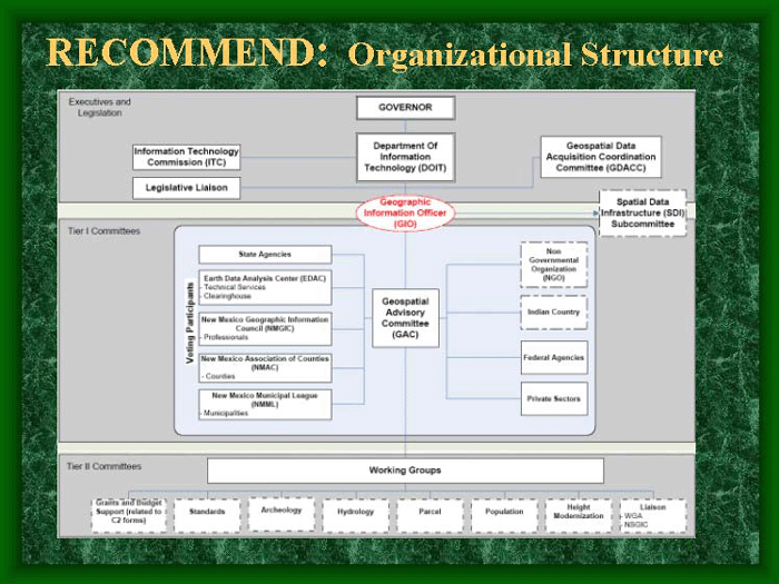
Statewide Strategic Planning
by Susan Smith
Recently I had requested information from organizations that had experience with developing statewide strategic planning and the acceptance and funding of a Geographic Information Officer (GIO) position. In response to that query, Tom Harrington, director of marketing and Rich Grady, CEO of Applied Geographics, contacted me to tell me about their experience in that area.
Applied Geographics has been directly and intensively engaged in statewide strategic planning for the last two years, starting with the development of the NSGIC Strategic and Business Plan templates in 2006. States they have worked with (or are currently working with) include: CT, CO, KS, MA, ME, NH, NY, RI, UT, and WY.
 [
Click to Enlarge ] [
Click to Enlarge ] |
“We are working with ten states on strategic plans and a large portion of those that are underway in this process are sponsored by FGDC and NSGIC. FGDC and NSGIC agreed that there needed to be state level planning efforts to address the nine criteria that they had defined for successful GIS programs,” explained Grady. “The GIO is just one of those nine.”
A GIO would be more focused on integrating the geospatial information with IT that the state has already. It would be a position beyond GIS coordination. Most states already have a state GIS coordinator.
A big part of the FGDC process is to reach out to all stakeholder groups. There are at least 12 identified groups that are either GIS consumers or producers, including tribal.
What were some of Applied Geographics’ experiences with getting a strategic plan and/or GIO in place?
“We developed a set of lessons learned from states we’ve been working with. There are some common approaches,” said Grady. “It’s not all struggle, I think that most states have some good history of GIS – it may be in one department or another, and typically that is the case. Part of the trend toward a GIO type role is to start to articulate where GIS should be managed out of as part of state infrastructure. Some alignment of what’s going on in IT is clearly needed, so some states are leaning towards the GIO being part of the IT organization, but typically that’s not where it’s started in most states. Some will probably keep it where it was originally developed but with more coordination.”
The role of the GIO, regardless of what department it is in, is to facilitate greater coordination of statewide efforts. “In every case we’re working with, they’re definitely looking beyond state agencies to try to gauge other stakeholders. I think a key success factor is to reach out to other stakeholders: academics, private sector, municipal government, tribal entities.”
Who is producing GIS data and who needs it?
“Another success factor is to identify the issues that can benefit from better coordinated GIS. It varies from state to state – issues vary – economic development, energy resources, natural resources, education, public health, the list goes on,” said Harrington. “Different states have their key issues and so tying into those usually involves a broader based approach, getting a political champion, involves outreach to the legislature, a full corps press to build awareness for GIS and get the support that’s necessary to fund it on a sustainable basis.”
What advice can you give to states to procure funding?
“An understanding of the budget cycle for your state helps. You have to know the right committees to talk to, you’ve got to start that process early…probably two years in advance, at least a year in advance, ahead of the budget cycle,” said Grady. “You need the right people and to know what’s coming down the pike.” It’s helpful to identify the committees that have GIS awareness, and can clearly see its benefits. The next step is to present the benefits and the business case to people who are responsible for making decisions about spending money. They don’t necessarily understand or believe that GIS is a good thing, but they want to know what it’s going to cost, what are some of the expected benefits, etc.”
 [
Click to Enlarge ] [
Click to Enlarge ] |
Those states that Applied Geographics have worked with that have specifically focused on creating, defining and hopefully winning legislative support for a GIO position, the process supported through the FGDC CAP grant was to lay out a strategic vision and to really put in place a business plan that makes the case in terms of the specific kinds of benefits that relate to objectives important to constituents and legislators. “We’re not at the point where the outcome is known yet for these states,” noted Harrington, “but by going through this process, the groundwork is laid for articulating benefits to the community of decision makers.”
Grady said that there is also a marketing dimension to the process, and one of the states they work with has developed a brochure that promotes GIS to non-GIS people.
Many states, such as New Mexico, have relied heavily on a volunteer effort comprised of people from various agencies to get tasks done that would ordinarily be assigned to a GIO. “That’s very true in many places,” said Grady, adding, “unfortunately that tends to create a certain false economy.
“As great as that spirit is, it’s hard to hold volunteers accountable for doing something on a deadline on a budget. It has to be put into perspective – the context of getting a problem solved on a schedule, with people held accountable, how do you that with volunteers with anything that you can really make stick?”
Grady pointed out that the uses of GIS are becoming more widespread and expectations for the availability of quality data are rising. GIS is growing at a rate that the volunteer effort cannot keep up with. “The volunteer effort doesn’t have the capacity to move the GIS program forward to the degree that it needs to moved, to really meet all of those demands. It naturally starts out with a lot of volunteer effort and the community of the willing, but then it reaches a stage where it can’t progress further without an injection of more sustained commitment. I think that’s the tipping point. The GIO is one of those tipping points, and legislation and funding is another tipping point that allows the state to move past that barrier. I think it’s then a natural lifecycle of the maturation of state GIS.”
Harrington concurred that it’s not unusual for states to use that approach to funding initiatives which is another false economy. “There may be the attitude that because they’ve been able to manage that way, why do anything different? That’s where some good business case analysis is needed. Success stories are part of that, but also failures – things that could not get done because the institutional support was not there.”
GIS is becoming ubiquitous and appearing in technologies that reach the masses, i.e. Google Earth and Microsoft Virtual Earth. Legislators and political leaders are going to be more familiar with those tools than something like ESRI. “States have to document their success stories, work the process, understand the budget cycle, understand the key committees, the legislators they should be in front of,” said Grady. “Ultimately they need sustainable funding to support a program that can be held accountable for results. Performance metrics are big in government right now. Traditionally they haven’t been big in GIS. Part of the FGDC process is to incorporate some thinking about performance metrics, namely a scorecard.”
Applied Geographics developed the process diagram shown in this article, for NSGIC and developed the templates for NSGIC, including the strategic planning process. ?We’re familiar with the whole process oriented approach and lessons learned from having done it as well,” said Grady.
The role of the GIO in Kansas is as a member of the IT department that coordinates the GIS program. “I think where it’s more likely to be called a GIO is where it’s actually aligned with the IT department or the CIO -- that’s certainly what they’re calling it in Wyoming and New Hampshire. Both those states have GIS coordinators and both are planning to do GIOs. In each case, the GIO will be housed in a different location than the GIS coordinator. That’s something else that varies from state to state.”
A key point for GIS, in terms of infrastructure, is that it needs some of the things that the IT department is building, noted Grady. “GIS is data intensive, where as most IT departments don’t really handle data per se, they handle the systems in the pipes that they’ll process and move data around, but individual departments tend to own their own data.”
There is a bigger burden on the GIO to understand data issues and to be more involved in coordinating data development. “There is a difference between a statewide street base or a statewide topographic layer and driver licenses or health care records. The GIO has to understand some thing about the geography and the specific details of each layer to ultimately be effective,” Grady explained. “In IT you have to be very familiar with the systems and architecture and different network protocols but I don’t think you have to be as knowledgeable about data specifics.”
That issue – where does it belong – is this a job for an IT person or a GIS person – is a question that is raised repeatedly in stakeholder workshops that Applied Geographics holds to educate the people about the bigger picture.
“We really try to fit it to the local landscape, and there are cultural traditions that have evolved around GIS because it is something that has been around for a long time,” said Harrington. There is a community of GIS people who are pretty knowledgeable in almost every state we’ve operated in and yet the politics and the issues and the business processes that are most relevant vary. We have to try to understand those and help the stakeholders navigate those waters.”
As part of the NSGIC process, there are two main components: the strategic plan (the vision, big picture – what and why) and business plan (actionable, implementable, programmatic – the need for a very specific plan). There might ultimately be a number of business plans, depending upon the number of programmatic goals you have. One might be to coordinate statewide ortho imagery, another might be to coordinate a mass address file, another might be to get funding and institutional support for GIL.
The three federal agencies that are most involved at this time seem to be USGS, DHS, and NGA.
Links:
Nine Coordination Criteria of NSGIC
Status of Individual States - NSGIC
A link to additional information about the state strategic and business planning templates (including the scorecard )
Top News of the Week
NAVTEQ Corporation, a global provider of digital map data for vehicle navigation and location-based solutions, announced that its stockholders have approved the previously announced merger agreement entered into with Nokia at the special meeting of stockholders held earlier .
Over 75% of the issued and outstanding shares of common stock eligible to vote, representing over 99% of the total votes cast at the special meeting, were voted in favor of the adoption of the merger agreement.
Adoption of the merger agreement by NAVTEQ stockholders satisfies one of the conditions to completion of the merger between NAVTEQ and Nokia. Completion of the merger is also subject to receipt of regulatory approvals and the satisfaction of the other closing conditions set forth in the merger agreement.
Acquisitions/Agreements/Alliances
Intermap Technologies announced an agreement with Magellan, one of the fastest growing GPS manufacturers in the world, to provide outdoor map content products for Magellan’s line of handheld GPS devices. Intermap’s AccuTerraTM map products will provide users with outdoor specific map data for the contiguous 48 states and Hawaii.
NAVTEQ, a global provider of digital map data for vehicle navigation and location-based solutions, announced the addition of American Digital Cartography, Inc. (ADCi) as a Zone Partner on the NAVTEQ Network for Developers (NN4D) site. ADCi joins current NN4D Zone Partners Autodesk and DeCarta in providing NN4D members with the resources and support needed for rapid development of next generation, location-based applications.
Atheros Communications, Inc., a developer of advanced wireless solutions, announced that it has signed a definitive agreement to acquire the assets and certain liabilities of u-Nav Microelectronics, a privately held fabless semiconductor company specializing in global positioning system (GPS) chipsets and software that enable mobile location-based products and services. The acquisition of u-Nav immediately expands Atheros’ growing product portfolio in mobile wireless communications which also includes mobile wireless LAN (WLAN), Bluetooth and PHS.
Descartes Systems Group, a global on-demand software-as-a-service (SaaS) logistics solutions provider, announced that it has acquired privately-held Burnsville, Minnesota-based RouteView Technologies, Inc.
RouteView provides technology solutions in a recurring revenue model to help small- and medium-sized organizations manage their delivery operations. RouteView's map-based routing software combines with wireless/GPS and automated call-out technology to help numerous customers, particularly in the home delivery and distribution industries, with a comprehensive delivery management solution.
Hemisphere GPS, a designer and manufacturer of advanced GPS products, has entered into a definitive agreement with BEELINE Technologies Pty Ltd. under which Hemisphere GPS has agreed to acquire all of the outstanding shares and ongoing operations of BEELINE for total consideration of US$21 million.
Announcements
The Open Geospatial Consortium (OGC®) announces a new category of membership, Aggregate Membership. It enables collaborating entities to bring their common issues and perspectives into the OGC process of developing interoperability standards. For example, state or provincial and local government agencies collaborate so that emergency response plans are fully coordinated. In this process, they identify and address barriers to interoperability. As an Aggregate Member of OGC, they will be able to influence standards, and to ensure that the process incorporates their requirements.
The Open Geospatial Consortium, Inc. (OGC) processes contributed to the interoperability achievements announced in the "GEOSS Report on Progress 2007" accepted by the Member Nations of the Group on Earth Observations (GEO) at their EO Summit in Cape Town on 30 November.
NAVTEQ, a global provider of digital map data for vehicle navigation and location-based solutions (LBS), announced a signed agreement with Wavefront—a new not-for-profit organization in British Columbia that provides test and commercialization services to developers of mobile applications—in which NAVTEQ, along with a select group of leaders in the wireless telecommunications industry, will become a founding member of Wavefront.
ESRI now offers a Small Municipal and County Government Enterprise License Agreement (ELA) Program that allows unlimited deployments of ESRI ArcGIS software to municipalities and counties in the United States. The program provides access to the geographic information system (GIS) technology small governments need with a straightforward, tiered pricing schedule.
- Updated versions of GIS software to provide a consistent platform
- Flexible deployments to desktops, servers, and mobile devices
- Opportunities to consolidate GIS and IT initiatives, establish internal standards, and integrate ESRI business partner solutions
- Ability to incorporate GIS into mission-critical applications and workflows
DriveOK™ Inc. a provider of GPS vehicle tracking units, announced the DriveOK™ Dealer Program, a dealer-only GPS tracking program for DriveOK™ distributors. This program provides maximum revenue potential for dealers that have experience with GPS systems and have an existing customer base.
ESRI has become a member of the GridWise Alliance to support developing technologies for the nation’s energy system. ESRI, the world’s leading developer of geographic information system (GIS) software, will work together with other GridWise Alliance members to advocate change and promote new policies.
New Products
ArcPad 7.1 and ArcPad Application Builder 7.1, the latest versions of ESRI's mobile GIS software for data collection and field mapping applications, have been released. The new enhancements in ArcPad 7.1 will help experienced users, as well as field personnel new to GIS, capture field data quickly and easily.
Blue Marble Geographics recently released Geographic Calculator v7.0, a major version upgrade that features a new Arc Extension, enabling users to access Blue Marble features directly in ESRI’s ArcGIS software. This exciting new capability for Calculator extends the power of ArcGIS as a geodetic definition and geospatial management interface. Blue Marble’s coordinate conversion technology is used worldwide by thousands of GIS analysts at software companies, universities, oil and gas companies, civil engineering, surveying, technology, enterprise GIS groups, government and military organizations.
DriveOK™ has launched a vehicle tracking unit that is extremely affordable, easy to use and provides significant value to small fleet owners and parents who want to monitor where their kids are driving. The OK232 has most of the commercial-grade features and has been provided at a fraction of the usual price for that type of service and capability. “The launch of our OK232 GPS Vehicle Tracking Unit brings an affordable unit to small fleet owners and families that have been reluctant to purchase a GPS tracking unit,” said Mark Wells, President & CEO of DriveOK™ Inc. “While most GPS tracking units cost more than $300, we are able to bring the cost down to $189.95 making it very affordable for everyone.”
IntelliOne, the premier traffic information company that measures speed instantly on virtually all roadways, announced an industry and market first: mashup of the Company’s Live!Traffic information for the greater Tampa, Florida area with Google maps. Unique to IntelliOne, coverage for the traffic congestion information includes freeways, highways and major city streets throughout Tampa-St. Petersburg. A link to the site may be found here.
Zoombak LLC, a Liberty Media company, announced that it launched its first Zoombak advanced GPS locators and related services for pets and autos. The Zoombak locator is now available for purchase online at zoombak.com, and at major national retailers in early 2008.
The Zoombak locator is one of the first Assisted-GPS (“A-GPS”) devices designed specifically for use by everyday consumers and will be sold nationwide at leading electronics and specialty pet retailers. Priced from $199 - $249, for pet and auto applications, respectively, Zoombak is smaller than a deck of cards and weighs less than three ounces, yet when activated can help find dogs and vehicles coast-to-coast, 24 hours a day and can promptly notify users about location by text message and email alerts.
3D Laser Mapping, the UK based laser-scanning specialist, has developed the latest version of its world renowned StreetMapper system specifically targeted at the mining industry. MineMapper uses the latest mobile laser scanning technology combined with high precision positioning systems to capture highly accurate and detailed measurements on the move. MineMapper is ideally suited for the mining environment as the system can be deployed on a range of vehicles to suit all terrains and when combined with 3D Laser Mapping’s SiteMonitor software can automatically create detailed 3D models of the mining operation including highly accurate depletion surveys, slope stability models, stockpile measurements and mine wide terrain map updates.
1Spatial have released Radius Check Lite™, a simple health check tool for Oracle-based spatial databases. This tool is available for free from the 1Spatial website. Working on both Oracle Locator and Oracle Spatial this tool provides a simple and easy-to-use way of validating the set-up of a spatial database. It is suitable for any user from a DBA through to the GIS user, and has the added benefit of actually educating the novice user about the conditions required for a spatial database.
Upcoming Events
| Mapping California Communities Workshop: An Introduction to GIS and Community Analysis | |
| Date: | January 10 - 11, 2008 |
| Place: | ExecuTrain 2901 K St
Ste 450, Sacramento, USA |
| Participants will learn how to easily create thematic maps of their own data and display spatial trends in information.
| |
| Mapping California Communities Workshop: An Introduction to GIS and Community Analysis | |
| Date: | January 16 - 17, 2008 |
| Place: | ExecuTrain 9841 Airport Blvd,
Ste 524 , Los Angeles, USA |
| Participants will learn how to easily create thematic maps of their own data and display spatial trends in information.
| |
| DGI Europe 2008 | |
| Date: | January 21 - 24, 2008 |
| Place: | QE II Conference Centre
Westminster, London, United Kingdom |
| DGI 2008 is Europe’s annual gathering of the defence geospatial intelligence community. Bringing together Heads of GeoINT, GIS, J2, C2, Imagery and Analysis, Reconnaissance, METOC, Operations and ISTAR, the conference provides a unique forum to discuss and debate the development of geospatial intelligence capabilities across the globe.
| |
| Mapping California Communities Workshop: An Introduction to GIS and Community Analysis | |
| Date: | January 23, 2008 |
| Place: | ExecuTrain 2005 De La Cruz Blvd,
Ste 200 , Santa Clara, USA |
| Participants will learn how to easily create thematic maps of their own data and display spatial trends in information.
| |
| Mapping California Communities Workshop: An Introduction to GIS and Community Analysis | |
| Date: | January 25, 2008 |
| Place: | University Business Center 5245 N Backer Ave,
PB 193 , Fresno, USA |
| Participants will learn how to easily create thematic maps of their own data and display spatial trends in information.
| |
| Mapping California Communities Workshop: An Introduction to GIS and Community Analysis | |
| Date: | January 31 - February 1, 2008 |
| Place: | ExecuTrain 210 Spear
San Francisco, USA |
| Participants will learn how to easily create thematic maps of their own data and display spatial trends in information.
| |
| 2008 MAPPS Winter Conference | |
| Date: | January 31 - February 4, 2008 |
| Place: | Westin Mission Hills Resort & Spa
Rancho Mirage, CA USA |
| The Management Association for Private Photogrammetric Surveyors (MAPPS) is the only national association of firms in the surveying, spatial data and geographic information systems field in the United States. MAPPS member firms are engaged in surveying, photogrammetry, satellite and airborne remote sensing, aerial photography, hydrography, aerial and satellite image processing, GPS and GIS data collection and conversion services. Our associate members include firms that provide products and services to our member firms, as well as other firms world-wide.
| |
You can find the full GISCafe.com event calendar here.
To read more news, click here.
-- Susan Smith, GISCafe.com Managing Editor.