


GISCafe Voice Susan Smith
Susan Smith has worked as an editor and writer in the technology industry for over 16 years. As an editor she has been responsible for the launch of a number of technology trade publications, both in print and online. Currently, Susan is the Editor of GISCafe and AECCafe, as well as those sites’ … More » Landsat 5 satellite on the blink, paves way for Landsat 8 scheduled launch 2013November 27th, 2011 by Susan Smith
According to a press release issued by NASA and the U.S. Geological Survey (USGS) November 18, the Landsat 5 Mission may no longer remain in operation. The reason for this is the USGS has stopped acquiring images from the 27-year-old Landsat 5 Earth observation satellite due to a rapidly degrading electronic component.
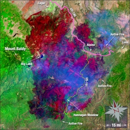
A Landsat 5 image of the Wallow Fire acquired on June 15, 2011. Landsat imagery courtesy of NASA Goddard Space Flight Center and U.S. Geological Survey When Landsat 5 was launched in 1984 it was designed to last 3 years. The USGS assumed operation of Landsat 5 in 2001 and managed to rescue the aging satellite back from the brink of total failure on several occasions following the malfunction of key subsystems. “This anticipated decline of Landsat 5 provides confirmation of the importance of the timely launch of the next Landsat mission and the need for an operational and reliable National Land Imaging System,” stated Anne Castle, Assistant Secretary for Water and Science at the U.S. Department of the Interior. “The USGS is committed to maintaining the unique long term imaging database that the Landsat program provides.” The amplifier that is in jeopardy is essential for transmitting land-surface images from the Landsat 5 satellite to ground receiving stations in the U.S. and around the world. In the past 10 days, amplifier problems have significantly diminished the satellite’s ability to down load images. Now USGS engineers have suspended imaging activities for 90 days so that they can explore possible options for restoring satellite-to-ground image transmissions. The USGS-operated Landsat 7 is actively in orbit collecting global imagery. Launched in 1999 with a 5-year design life, Landsat 7 has experienced an instrument anomaly which reduces the amount of data collected per image. A new satellite, Landsat 8, currently named the Landsat Data Continuity Mission, is now scheduled to be launched in January 2013. Tags: GIS, Goddard Space Flight Center, imagery, Landsat 5, Landsat 7, Landsat 8, NASA, National Land Imaging System, satellite, satellite imagery, US Dept. of the Interior, USGS, Wallow Fire |
|
|
|
||||
|
|
|||||
|
|||||


 Animation, 3D Art and 3D Models")