
Warning: Undefined array key "upload_with_nude_flag" in /www/www_com/htdocs/get_weekly_feature_ad.inc.php on line 69
Welcome to GISWeekly!
GISWeekly examines select top news each week, picks out worthwhile reading from around the web, and special interest items you might not find elsewhere. This issue will feature Industry News, Top News of the Week, Acquisitions/Agreements/Alliances, Announcements, People, New Products, Around the Web and Events Calendar.
GISWeekly welcomes letters and feedback from readers, so let us know what you think. Send your comments to me at Email Contact
Best wishes,
Susan Smith, Managing Editor
Industry News
Utility Challenges, ROI with Autodesk Topobase and the New Topobase Electric
by Susan Smith
In a business value analysis white paper written by analyst IDC this month, the following statement was made: “The payback period from deploying the Autodesk Topobase solution averaged 11.6 months for the companies surveyed, yielding an average return on investment of 518%.”
This figure on ROI is significant and included users of all Autodesk products including AutoCAD, AutoCAD Map3D, Autodesk Utility Design, MapGuide, and Topobase. The largest area of benefits came in hard costs reductions. According to IDC, they found that the companies surveyed were able to increase benefits of $2.9 million per year, increase their project load by 31% yet reduce their equipment and operational costs by an average of $1.8 million per 100 users. Half of the companies surveyed were government organizations, and as such their revenue was controlled and growth was limited. Even so, on average, companies were able to increase their revenue by almost $100,000 annually per 100 Autodesk users.
 [
Click to Enlarge ] [
Click to Enlarge ] |
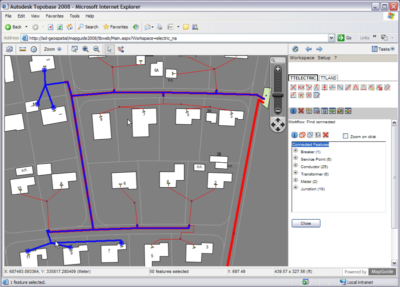
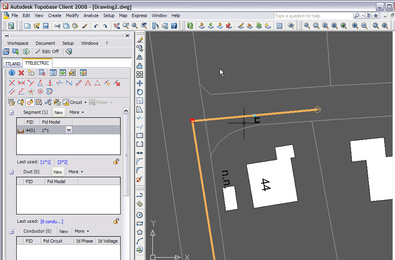
Topobase has over 500 customers worldwide. The product is built on AutoCAD Map 3D and Autodesk MapGuide Enterprise. It has a very powerful desktop platform based on AutoCAD Map 3D and a web based platform that allows you to share that information using a simpler client, on the web. At the back end is the Oracle Spatial database that helps to manage that information effectively.
 [
Click to Enlarge ] [
Click to Enlarge ] |
With the release of Topobase Electric, Arnab Ganguly, technical marketing manager for Topobase and Jerry Labay senior marketing manager Geospatial spoke on Autodesk’s position in the Utilities market and the challenges that utilities face.
Arnab Ganguly cited four categories of challenges:
1) Aging infrastructure – The utility infrastructure in place right now is coming toward the end of life. Several utilities want to revisit the status and capabilities of these networks, and that’s always a compelling reason to look at the system that manages that infrastructure.
2) Knowledge transfer – A lot of the experienced staff are eligible for retirement, resulting in really experienced people being replaced by people who are not that experienced. “That has led us to look at software and software systems to automate a lot of the processes that previously could be done manually,” said Ganguly. “We are effectively allowing the software to take a role in making sure the utilities are standard and maintained when new work is done.”
3) Rapid growth in cities, such as Las Vegas, has brought about a substantial need for redevelopment, improvements to existing infrastructure as well as building new infrastructure to manage the growth.
4) Regulatory compliance – Reporting requirements that utilities are faced with are a compelling reason to have a system to generate these reports.
Autodesk’s approach to these challenges is to improve business process and data quality by effectively starting with the engineering and design process where they are traditionally strong.
“With the addition of Topobase to that design phase, we incorporate solutions that help you operate and maintain that infrastructure that utilities are working on,” Ganguly stated. “By enabling the movement of that design information that’s created on an AutoCAD-based platform, using AutoCAD Map 3D and Utility Design, and integrating that data into an Oracle-based database, we are making that information available to other departments in the organization. Utilities can see the big picture. What was conceptualized from a design point of view is available to everyone.”
Designers themselves benefit from information maintained by the other departments. For example, someone in the maintenance and operations department of the business may be managing some of their information or providing updates to some of the data maintained in that data store with Topobase. This information is then available to designers to help them make better decisions.
 [
Click to Enlarge ] [
Click to Enlarge ] |
“With Topobase we now have the ability or a better way to make this information available to the right people at the right time,” said Jerry Labay. “The fact that you have integrated your CAD data, which traditionally tends to be very file based, into a centralized data environment, automatically means that people from finance and customer service, maintenance and operations can access that information. A lot of traditional design intelligence is available through this centralized database for use by those other departments.”
As Autodesk’s integration platform for infrastructure design and management, Topobase provides an Oracle database for you to store your CAD design information. Oracle Spatial can store spatial geometry, which you can continue to use with those file-based, CAD-based tools and the AutoCAD-based products, and have that information stored in the Oracle database. The information is readily available and users outside the design space can access it much more quickly.
Topobase has the ability to enter data using step by step workflows. It validates information as it is entered. Users follow simple steps to enter the data in the database, which reduces the chances of errors, and improves the quality of data that is maintained within.
The Las Vegas Valley Water District have integrated their engineering information in Topobase with their ESRI/ArcSDE database which houses their land parcels. While they are in Topobase, they will flag any areas where the Topobase database is a little bit different than the ESRI database. This way, engineers who are entering the information can figure out what the correct information is and put it in both systems.
If Topobase has accurate information such as GPS points and its information is different from parcel information received from ArcSDE, for example, users can use a notification pop up to let them know of the discrepancy and decide whether to fix it or not. Instead of automatically changing the information in the database, Topobase automatically flags it. If it is changed within Topobase it automatically changes in the ESRI ArcSDE database.
Topobase also stores relationships within the database, and has the rules and topological relationships that make design data entry a lot more seamless.
Technical features of Topobase Electric:
1) Data model for transmission and distribution. This data model includes transmission to and from a substation, then passes it out to commercial and housing areas. It enables you to store both structural and electrical assets. “Structural assets” include manholes and underground ducts, towers, any physical assets that would hold electrical assets. Electrical assets are what form the circuit or the network and consist of transformers, conductors, fuses, switches, etc.
2) Connectivity. Checking for connectivity includes doing a trace to find an open switch but this can also be done physically from a fieldworkers’ point of view. Topobase Electric also has some industry workflows and business rules so that a user can say, show me all the open devices coming from my circuit breaker. It has the ability to manage overhead as well as underground utility data.
3) Infrastructure utility data tends to be more complex because there is more happening within those assets. “For example, if you look at a conduit, or electrical duct, it may have multiple cables within to form a part of a circuit,” Ganguly explained. “Traditionally, from a representational point of view, you represent that by a line, but there is more happening within that line that tends to be more than you visualize. Traditionally, you would pick that line and see a text box showing all the conductors within. With Topobase we give you a graphical view that allows you to visualize that cross section, to actually feel the conductors that fit within that duct. You can define the type of duct it will be, which automatically defines the number of conductors you would have for the specific duct. Once you have that, you can insert your duct, and it automatically detects what it’s connected to. If it’s an extension to a existing circuit, it will automatically inherit the value of that circuit.”
4) Smart assemblies allow you to automatically insert into the database multiple assets that are related in one step.
5) Electrical connectivity tools allow you to connect upstream and downstream, and allow you to create space in certain phases. You might have some residential housing that’s fed by multiple phases and you can do a trace to find out which houses are being fed by which phase. This functionality would be very useful to customer service, and maintenance and operations field workers.
6) A cross section view enables a user to visualize all complicated data that might be housed within a single representational line. From a real world perspective, that line is actually a physical 3D dot, which has multiple conductors within. This capability allows the user to visualize these complex layouts of assets right on the screen, and automatically visualize what it looks like within that dot.
Top News of the Week
Garmin Ltd. announced that its subsidiaries, Garmin International Inc and Garmin Corporation, have signed a six-year extension to their agreement with NAVTEQ, a provider of digital map data for location based solutions and vehicle navigation. The agreement allows Garmin to continue using NAVTEQ data through 2015, with an option to renew for an additional four-year period. In addition, the parties have agreed to pursue expanded points of cooperation that will result in improved mapping quality and coverage worldwide, and will drive further device innovation into the future. The parties did not disclose specific details of the agreement.
Infoterra France, a provider of geo-information products and services for managing the development, environment and security of our changing world, has landed an agreement with popular search engine Google, to provide them with a unique image processing technology that will be employed in particular to process geographic images. This technology inherits from more than 15 years of Infoterra France experience in the domain, having led to world class products such as the Pixel Factory.
Acquisitions/Alliances/Agreements
MapQuest, in partnership with Telmap, announced that the newest version of its voice-guided, GPS-enabled wireless application, MapQuest Navigator 5.0, is now widely available to consumers through a new direct-to-consumer storefront on MapQuest.com. Customers, including the 50 million monthly MapQuest.com users(1), who sign up for new version 5.0 at the MapQuest Navigator link between now and December 31, 2007 can download the application directly to their handset and purchase the service for the promotional price of $4.99 per month for the life of the subscription.
In addition, MapQuest(R) Navigator 5.0 includes feature enhancements such as live traffic, gas price and station locator, and City's Best(R) ratings from AOL(R) CityGuide.
ESRI and Hart InterCivic, Inc., have expanded their relationship to develop and offer geographic information system (GIS) solutions to the election community. This is the first time GIS-enabled election management solutions will be commercially available and marks a significant opportunity for state and local governments to enhance election processes. The initial offerings will focus on real-time election results and polling place locator applications.
Avatech Solutions, Inc., the technology experts for design, engineering, and facilities management, has become a high definition scanner Gold Dealer with Leica Geosystems. Avatech is among the largest US distributors for Leica Geosystems high definition scanners (HDS), serving companies engaged in surveying, plant design, architecture, and facilities management.
Telog Instruments Inc. (Victor, N.Y.) the supplier of remote monitoring systems to the water markets, and Wallingford Software Limited (Oxfordshire, England), the developer of hydraulic modeling software for the water industry, have agreed to collaborate on the development of a real-time, networked water modeling application.
The application solution combines Telog’s Enterprise data acquisition system with Wallingford Software’s InfoWorks modeling software application to provide calibrated, real-time website hosted information on environment water events and forecast management. This will allow users and emergency response teams to more accurately deploy resources during storm events.
ESRI Canada is pleased to announce their partnership with Keigan Systems Inc., developers of CLEER™ (Catastrophic Level Event Emergency Response). Keigan and ESRI Canada have partnered to provide a complete web-delivered decision support system for public safety and emergency management and preparedness. CLEER – ESRI Version uses a blend of digital maps, ongoing field output and sophisticated Intellectual Property (IP) to arm first responders with a highly visible, real-time, mapping portal from which to manage an entire catastrophic event.
Announcements
The Open Geospatial Consortium, Inc. (OGC(R)) seeks public comment on a draft Sensor Alert Service (SAS) Standard.
The draft OGC(R) Sensor Alert Service standard defines an alert and notification mechanism that specifies how alert or alarm conditions are defined, detected, and made available to interested users. The Sensor Alert Service uses the Extensible Messaging and Presence Protocol (XMPP) to provide the push-based notification functionality. The focus of SAS is on alerts from sensors and sensor webs, a more narrow scope than a complete Web-wide alerting service.
This draft standard can be downloaded from the OGC Standards/Requests 44 website .
Garmin has announced that Volvo Cars Corporation has selected the nüvi 760 as a customized navigation solution for select Volvo cars, including the new Volvo C30 and Volvo XC70. The Volvo specific nüvi 760 will be available at dealerships across Europe and North America.
PCI Geomatics, a developer of software and solutions for geospatial imaging applications, is pleased to announce its support of image products from the satellites WorldView-1 and TerraSAR-X, and enhanced coverage for ALOS (Advanced Land Observing Satellite) in the form of additional JAXA (Japan Aerospace Exploration Agency) files support.
People
CARIS, the provider of marine and hydrographic software, has appointed Mark Matthews as Senior Business Developer to focus on fostering business opportunities for the company’s complete Ping to Chart product line across Asia Pacific.
Prior to joining CARIS, Mark began his career as a Hydrographic Specialist with the Royal Australian Navy (RAN). Mark joined the RAN in 1985, and specialized as a Hydrographic Surveyor in 1990.
Bohannan Huston, Inc. (BHI) of Denver recently hired Loretta Davis as Vice President of Business Development and Marketing. Loretta has 19 years of business development experience in the spatial data, GIS consulting, and IT professional services industries. Loretta formerly served as Director of North America Business Development for Atos Origin, a global IT services company nationally headquartered in Houston, Texas with corporate headquarters in Paris, France. Loretta will be responsible for all marketing and business development activities and will assist in expanding Bohannan Huston’s business into new markets and regional locations.
New Products
ESRI (UK), the provider of geographically enabled software solutions, has announced the launch of Productivity Suite 1.1 and LocatorHub for UK-based Geographic Information System (GIS) professionals using ESRI’s ArcGIS 9.2.
Productivity Suite 1.1 now supports Ordnance Survey’s (OS) Integrated Transport Network dataset, enabling easy interpretation of the data for route planning with ESRI (UK)’s Network Analyst product, without the need for complex coding. For example, local authorities can plot the most efficient routes for buses or rubbish collection using this feature, quickly and simply.
Bentley Systems, Incorporated has begun shipping StormCAD V8 XM Edition, an easy-to-use storm sewer network design and modeling solution that is the first to offer multiplatform interoperability. StormCAD was identified as the No. 1 hydraulic modeling solution for stormwater networks in a recent national survey.
3D Laser Mapping has developed a mobile cityscape mapper that captures highly accurate 3D modeling data of buildings and streets. The development is an enhancement to StreetMapper, the vehicle-mounted laser mapping system that is already well proven in terrain and highway mapping.
Around the Web
The Paperless Map Is the Killer App November 26, 2007, Business Week - Forget media downloads. Cell customers really want GPS and navigation features.
Upcoming Events
| Autodesk University Annual User Conference and Exhibition | |
| Date: | November 27 - 30, 2007 |
| Place: | The Venetian Resort Hotel
Las Vegas, USA |
| The 15th annual Autodesk University (AU) at the Venetian Resort Hotel in Las Vegas is not until November, but if you’d like to teach a class, please submit your ideas by April 30th. Take a moment to submit your proposal at the AU 2007 website. After providing some personal information about your expertise on a secure server, you’ll be able to submit one or more proposals for classes.
| |
| Second Annual International Airport GIS Conference | |
| Date: | November 28 - 30, 2007 |
| Place: | Kempinski Hotel
Budapest, Hungary |
| By attending this unique conference, you will learn from European, U.S. and other international airports how and why GIS is being used at large and small airports, as well as the ways in which GIS has made airports safer and more efficient. The primary focus of the conference is to exchange new ideas, success stories and lessons learned on how GIS and related technologies are applied at airports. The conference will include presentations on how airports have used GIS to support security, operations, planning, design, construction, maintenance and much more. New geospatial technologies and approaches for applying these technologies will also be showcased. Additionally,
strategies for managing and funding a GIS program will be discussed. The conference will also have an Exhibit Area showcasing the latest GIS-related products and services.
| |
| Geodiffusion 2007 | |
| Date: | December 3 - 5, 2007 |
| Place: | Montreal, Canada |
| The sixth edition's program will mainly focus on products and solutions from business intelligence and gesopatial industry leaders: PB MapInfo and Oracle. Geospatial Data from global providers will also be part of the agenda.
This event offers a unique chance to acquire expertise, discover new technologies and learn more about geospatial and business intelligence. No matter their industry segments, decision makers and C-level executives, integrators and IT managers, users and GIS experts benefit from this occasion to discuss a subject that matters to them: business intelligence and geospatial. On the agenda: kick-off reception, conferences, breakfast and luncheon meetings, hands-on lab, exhibit hall and dinner.
| |
| 4th Annual U.S. Commercial Remote Sensing: Next Generation Satellites | |
| Date: | December 3 - 4, 2007 |
| Place: | Marriott
Metro Center, WA USA |
| Over the past decade the commercial remote sensing industry has experienced significant technological changes and improved market penetration. This fall the industry will be one of the next wave of the most technologically advanced satellites to ever exist will be launched. Faster data distribution rates and enhanced imagery processing and packaging services will drive the growth of the commercial remote sensing market. Next Generation Satellites will give way for an unprecedented level of sensing information capabilities.
| |
| 3rd International conference “Earth from Space - the Most Effective Solutions" | |
| Date: | December 4 - 6, 2007 |
| Place: | R&D Center Scanex
Moscow, Russia |
| The conference is attended by around 300 participants from different countries, representatives of the world leading remote sensing programs, data processing software developers and receiving stations producers, as well as members from different organizations and leading specialist that use remotely sensed data for decision making to resolve a variety of practical tasks: from management of territories and big industrial facilities to real-time monitoring.
| |
| 3D GeoInfo'07 | |
| Date: | December 12 - 14, 2007 |
| Place: | Aula Conference Centre of Delft University of Technology
Delft, Netherlands |
| The Workshop is intended as an interactive platform for both presentations on state-of-the-art research and discussions on open problems. The workshop will consist of a mixture of single-track presentations and discussion (PD) sessions and parallel working group (WG) sessions on specific themes (Requirements, Acquisition, Modelling, Analysis, Visualisation), according to the following format: current problems to be solved, potential solutions, and recommendations by WG (discussion under coordination of a chair and final presentation of the results at the closing plenary session). The presentations will be selected based on their quality by the scientific program
committee (peer review of full papers). The setting of this innovative event will be the ancient city of Delft.
| |
You can find the full GISCafe.com event calendar here.
To read more news, click here.
-- Susan Smith, GISCafe.com Managing Editor.